Requesting buffered bike lanes option for "Bike paths" quest #5899
Comments
|
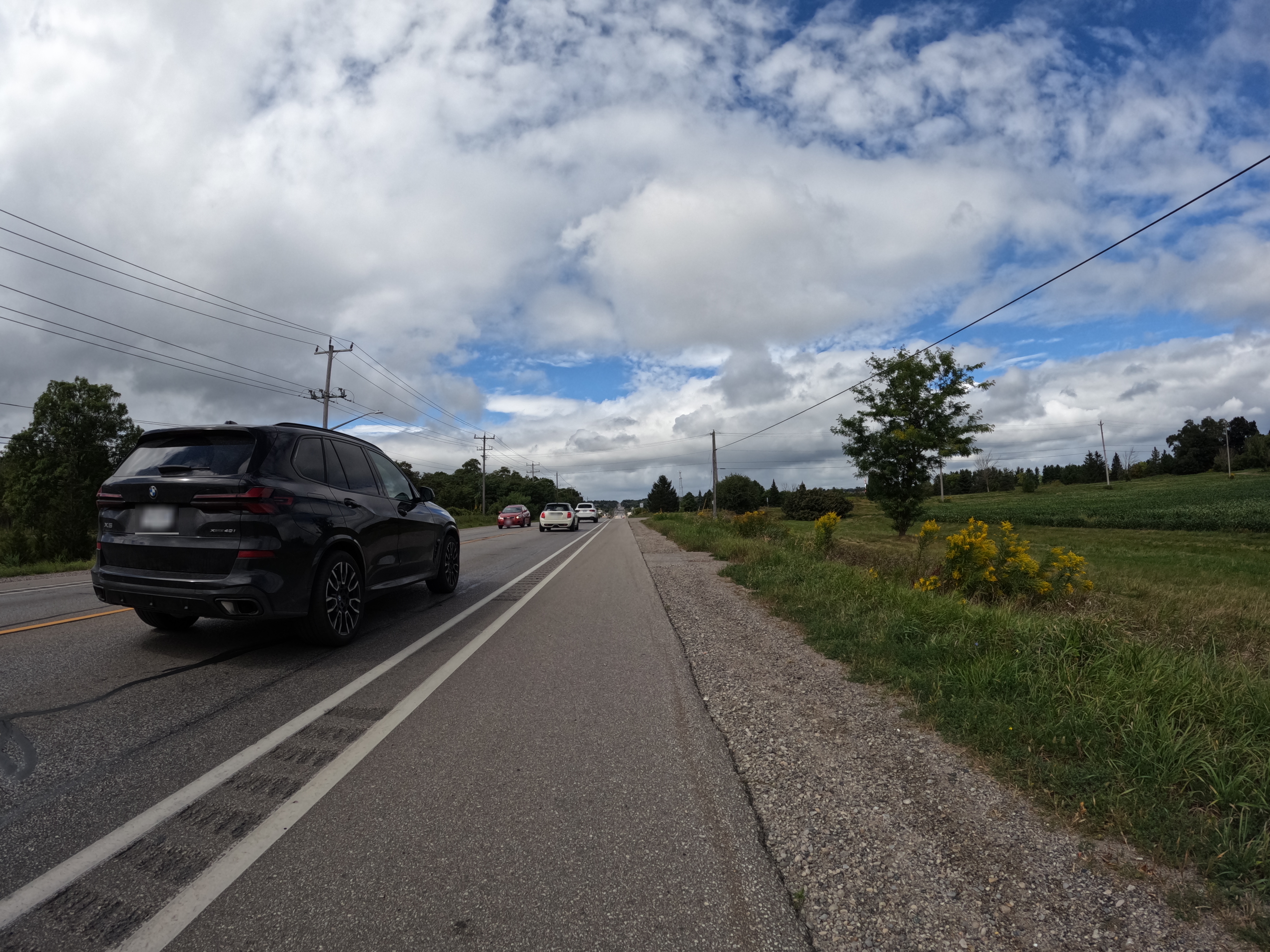
Buffer like one on this photo is basically not changing anything... |
Can you please clarify whether you're referring to changing anything safety-wise or in StreetComplete? Regarding safety, fully protected bike lanes with a physical barrier would be far superior to these painted lines. However, driver behaviour somewhat improves when there are two lines so it's clearer that it's not a shoulder, as well as rumble strips. Unfortunately, in much of my country there are only standard or buffered lanes with very few safe, protected lanes. Regardless, the distinction between the two is meaningful and well-documented in city planning. |
first one - I have serious doubt about usefulness of collecting data how wide this painted line is (as a cyclist) |
That is fine, because this proposal is to include yes/no. I agree that it's questionable to go so far as to specify the width. :) |
|
Hm, this tag is not really in use yet. After Other than that I tentatively agree with @matkoniecz that this road looks really unsafe for cyclists (with or without double-stripe), I think it would be more meaningful to ask for both the left side and the right side of a cycle lane (for each side), because within cities, you have cycle lanes sometimes that are close to the parking lane without buffer. The UI would be difficult for that, though. On the other hand, most traffic regulations I know define certain minimum requirements for cycle lanes and having a sufficient distance to the doorzone of parking cars is usually part of these requirements. Thus, it would be spammy to ask about the buffer in such countries. Also, might be difficult to ask users to "buffer, yes or no?" because at least according to the values tagged so far, a buffer is not a buffer - the widths and thus the perceived safety seem to differ widely. |
more specifically: I would not really guess that this specific one is supposed to be counted as having a buffer |
The wiki states "If no unit is given, the default is meters."
I definitely agree that this is unsafe too. The paint does not protect you from a motor vehicle on a fast-moving road. In much of Canada and the USA outside of major cities, the bicycle infrastructure is significantly worse than in Europe, so the distinctions between a standard and buffered lane become more important. Unfortunately, in most of Canada outside of a couple major cities, this is the best we get. Standard Bike Lane: Buffered Bike Lane:
I really like the current, existing functionality where it asks if there's a bike lane on each side. I am suggesting that we add an additional option for buffered bike lanes. Without this option, the closest choice is either standard "bicycle lane" (inaccurate) or "sidepath or protected bicycle lane" (even more inaccurate). Here is a mock-up I made for clarity 🙂 (I just added it to the original issue description)
IMO it is best to stick with yes/no to indicate that a buffer exists. A buffer is simply a standard bike lane with a second line. By definition, it is a wider bike lane which marginally increases safety and makes it clearer to avoid card parking in bike lanes (a chronic and unenforced problem here). I'd also like to add that buffered bicycle lanes are used by both advocacy groups in Canada and officially recognized by governments and municipalities in Canada and USA. It is a standard term in city planning where I live. As a result, it's useful to have this information in OSM and to avoid it being overwritten by less accurate bike lane types. Examples of buffered bike lane usage across Canada and the USA: |


|
Also, please note that I would be happy to make this change myself with permission from the devs. 🙂 |
|
I still have problem about increasing form complexity. In terms of other dubious improvements I have seen for example:
All this seems in the same category of marginally improving safety, but being no substantial improvements - like that wide painted lane. |
|
Would we want listing of all of them? Almost certainly no. Would we want specifically "40 cm wide painted lane" specifically? Why that and no other? What if someone will arrive next and start to ask to provide option to tag also other similar things? |
|
I'm on the edge about including that option in StreetComplete. On the one hand, it has some use and seems deterministic; but on the other hand, it might confuse users (especially non-cyclist ones, or the ones whose country does not have those) as introducing another option between "protected bicycle lane" and "(unprotected) bicycle lane" leading to analysis paralysis. So perhaps such additional answer option might be better fit for SCEE (StreetComplete "Expert edition" fork) which is open for quests requiring domain expert knowledge (and which might also be open to followup quests on e.g. Another option is only showing that option in StreetComplete only in countries where it is popular, but that requires complexity and research to update https://github.com/streetcomplete/countrymetadata (akin to e.g. hasAdvisoryCycleLane.yml) |
|
As others have written, whether or not a cycle lane has a double line to other lanes is just one of many separation features that might be recorded. The following is just a proposal - https://wiki.openstreetmap.org/wiki/Proposal:Separation - but it contains a lot of examples and photos by which things or markings a cycle lane or cycle track can be separated from other lanes. And to record this seems to be more relevant to me than just the buffer width via the markings. It for example makes a big difference if the buffer is filled with jersey barriers or not. Now, that proposal looks kind of incomplete, e.g. the separation seen in your first photo - a rumble strip - is missing from that proposal. Also, given the complexity of all this, I do wonder whether it wouldn't be simpler to just map every cycle lane that is protected in some proper way (jersey barrier, kerb, greenery, guard rail, .... but not rumble strips or studs) as a separate way in OSM or at least map it as |
|
Given the amount of usage of them in the US and Canada it's worth adding this as an option for those countries, as its a significant improvement in visibility and thus safety and usually comes with a better overall planning for the infrastructure itself. So if two parallel roads are an option from point A to B I would always choose the buffered bike lane. That's reason enough to tag it and also ask for support in routers for favoring this. The term itself seems to be well established, so I don't see an issue with the tag in use for yes/no, even if it's low in use right now. However I wonder if it would make sense to break the quest up into three questions:
The list is now, as several have pointed out, already pretty long right now and it's getting pretty hard to answer in a oneshot, as stuff like "which type of line seperate the lane painted on the road? ", "is this for one or two directions?", and "is there a cycleway at all?" are mixed together. This would considerably reduce the options a user has to scroll through for each step, while the effort should stay pretty much the same. |
Use case
In Canada, many cities publish bike maps which distinguish between standard bike lanes and "buffered bike lanes". Buffered bike lanes are important information on busy, fast-moving streets since they offer more safety than a single painted line. They are defined as a dedicated bicycle lane with double lines of white paint to separate the cyclist from traffic. They may also have diagonal striping or rumble strips between the double lines. This is different than the existing "sidepath or protected bicycle lane" because buffered bicycle lanes are level with the road and are unprotected by bollards/concrete/etc.
Proposed Solution
The cycleway:buffer=* should be tagged in conjunction with cycleway=lane. Use cycleway:right:buffer=* and/or cycleway:left:buffer=* to tag different buffers on either side of the road. The buffer value may be yes, no, or a number indicating the width of the buffer. I propose that we use yes or no for simplicity. The width of the buffer could potentially be a separate quest.
It could be drawn in OpenStreetMap as the same as a bicycle lane, but with two lines.

Example:
 source
The text was updated successfully, but these errors were encountered: